

Choose Your Own Adventure!
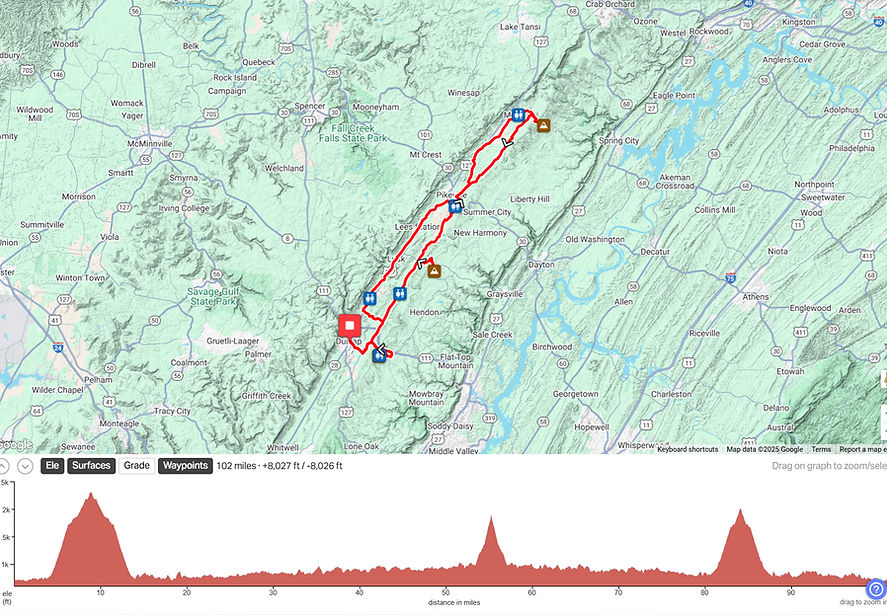
Cycle Sequatchie has four base routes to choose from: 15, 35, 50 and 80 miles, plus three optional climbs. You can stay in the valley and ride the rolling hills found on the base routes or you can add more challenge & distance by taking on the optional out & back climbs. Combine the 80-mile base route with all three climbs and you'll have 102 miles and 8,000 feet of climbing!
We also offer two mixed-surface routes (40 and 64 miles) that provide access to some hidden gems in Sequatchie Valley accessible only by unpaved (or barely paved) roads. See below for more details about these special routes!
If you take on any of the climbs or complete a mixed-surface route, don't forget to stop by the Cycle Sequatchie tent near the lunch area when you finish to receive your reward!
Please be advised that the optional climbs are super steep and on narrow backroads with very rough pavement. Experienced cyclists only - with disc brakes!
If you're looking for a short shakeout ride on Friday or recovery ride on Sunday, we've provided a couple of options at the bottom of the page. These routes are self-guided and will not be marked on the roads.
And if you've got little ones who want to get in on the action, we have a free 2-mile kids ride on Dunlap's Coops Creek Greenway Saturday morning at 9:15!
BASE ROUTES
15-MILE ROUTE: A great introduction to cycling in Sequatchie Valley with plenty of rolling hills and nice views of the valley & ridges. Click below for a downloadable map.


REST STOPS
The rest stop at the Dollar General is provided by our friends from the Sequatchie Valley Cycling Club, and it's the first rest stop on all of the base routes except the 15-mile route (which doesn't have a rest stop due to the short length of the route). If you don't do any of the climbs, you'll hit this rest stop around mile 11.
3 MTN CHALLENGE
FULL CENTURY (Henson Gap first): To complete the century, combine the 80-mile base route with all three climbs. 102 miles, 8000 feet of climbing. Click below for a downloadable map.
PLEASE NOTE: In order to continue on the full century route, you must reach the Church of Christ rest stop at mile 26 by 11:30. After 11:30, all cyclists will be redirected to return to Dunlap via the 50-mile route.
.jpg)
.jpg)
THE CLIMBS
5.1 miles to the top / 1,600 feet of climbing
HENSON GAP is the longest of the three climbs, but it rewards those brave enough to take it on with a spectacular view overlooking Sequatchie Valley (along with a rest stop). With its location just a few miles from our home base in downtown Dunlap, Henson Gap can be attempted right off the bat when your legs are still waking up, or you can save it for the end when your legs are potentially cooked from a long day in the saddle. Your call. The climb consists of two parts, with a consistently steep first part that includes a nasty "S" curve with grades in the high teens. After grinding out the first three and a half miles on Henson Gap Road, you'll then turn onto Window Rock Road and continue uphill with a series of steep ramps before finally reaching the rest stop at the Tree Toppers hang gliding launch pad. The descent requires sharp focus and steady braking to ensure that your speed remains under control, especially prior to entering the "S" curve, which is not only the steepest and curviest part of the descent but also has the worst pavement. Use extreme caution and don't cheat the corners. This climb/descent has terrible pavement with numerous potholes and is for experienced cyclists only. Don't underestimate the grades and curves!


MIXED-SURFACE ROUTES
The mixed-surface metric century includes 7 unpaved (or barely paved) sectors, one never-ending climb up the Cumberland Plateau, and one never-ending descent! Roughly 75% paved/25% gravel & trashy asphalt. 65 miles, 5000 feet of climbing. This route WILL NOT BE MARKED. This is a challenge for experienced cyclists only and requires the ability to self-navigate and manage road surfaces not suitable for skinny road tires. Click below for a downloadable map.


FRIDAY SHAKEOUT / SUNDAY RECOVERY
COOKIE JAR LOOP: Starting and finishing at the Cookie Jar Cafe, this 27-mile loop will wake up your legs with plenty of short hills along with plenty of great views! It also features stops at the historic Coke Ovens, Veterans Park, and Clarks Bakery. Click below for a downloadable map.

